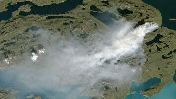
Satellite data show openings in the canopy of Europe's forests, as shown here on an area of the Bavarian Forest. Due to the bark beetle these spruces have died in the Bavarian Forest National Park. Rupert Seidl and his colleague Cornelius Senf have mapped the data from 30 years for the first time.
Satellite data show openings in the canopy of Europe's forests, as shown here on an area of the Bavarian Forest. Due to the bark beetle these spruces have died in the Bavarian Forest National Park. Rupert Seidl and his colleague Cornelius Senf have mapped the data from 30 years for the first time. Newly created map indicates openings in the European forest canopy - The forest canopy (the closed vegetation cover consisting of treetops) is rapidly declining according to a research team from the Technical University of Munich (TUM) and the University of Natural Resources and Applied Life Sciences, Vienna. The team used satellite images, to create the first high-resolution map of canopy openings in Europes forests and reached the conclusion that the canopy of more than 36 million forest areas has been lost over the past 30 years. According to Rupert Seidl (professor of Ecosystem Dynamics and Forest Management in Mountain Landscapes at the TUM) and his colleague Cornelius Senf (lead author of the study) for the first time a research team has succeeded in producing a high-resolution map of all openings in the canopy of European forests. They have analysed more than 30,000 satellite images and identified more than 36 million areas where large trees have given way to open spaces of young trees.
TO READ THIS ARTICLE, CREATE YOUR ACCOUNT
And extend your reading, free of charge and with no commitment.